Survey Of The Megalithic Tombs Marblehill
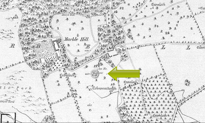
This survey gives the exact dimensions of the tombs that are found today on the townland of Marblehill.
26. Marblehill. O.S. 125: 6: 2 (35-8 cm. 38-2 cm.). “Cromlech.” O.D. 400-500.
M 688 041. Fig. 11. Plate 8.
Portal-tomb
The three tombs in Marblehill demesne, Ga. 26, Ga. 27 and Ga. 28, are situated
on rolling land about \ mile north-west of Ballin Lough. Much of the land on the estate
is under forestry plantation but the open ground is devoted to meadow and pasture.
The estate is overlooked by the wooded heights (600 ft.) west of Marble Hill House.
This, the most northerly of the three sites, is situated on sloping meadow land,
about \ mile north-east of Marble Hill House. It consists of a small ruined chamber,
about 2 m. long, with the entrance towards the south. The east and west sides of the
chamber each consist of a portal stone and one sidestone but both stones at the east
have collapsed inwards. A displaced stone lies immediately in front of the entrance
and two others occupy the northern end of the chamber. Resting above the chamber
is a large roofstone which appears to have slipped somewhat northwards with the
collapse of the chamber. The structure is surrounded by a small low mound about -40 m.
high. Its perimeter is difficult to define because of the slope of the ground and its
present outline may, in fact, be largely the result of cultivation. A prostrate stone,
•85 m. by at least -40 m. and -20 m. thick, lies on the mound immediately north of the
roofstone. About 1-20 m. west of this is a small stone, -30 m. long, -15 m. thick and
•30 m. high, which appears to be well set in the ground but it may only be a fortuitously
exposed cairn stone.
The western portal stone is a pillar-like block, -50 m. by -45 m. and 1-05 m. high.
The collapsed portal, at the east, is -8o m. long, -35 m. thick and would be about the
same height as the opposite portal if it were erect. The original position or function of
the prostrate stone in front of the portals is not clear. It is -85 m. long by at least -40 m.
wide and -20 m. thick. The erect (western) sidestone is 2-00 m. long, -25 m. thick and
•65 m. high. The opposite sidestone has fallen inwards and its southern end overlies
the portal. It is at least 1-50 m. long and -15 m. thick and would be about -50 m. lower
than the portal if both stones were erect. The two stones at the north end of the gallery
are of uncertain function though the larger may perhaps be a displaced backstone.
The more easterly of these is -75 m. by -20 m. and would be -55 m. high if erect. The
second stone is 1-25 m. by 1-10 m. and -15 m. thick. The roofstone is about 2-50 m.
long and -55 m. thick. It narrows from 1-90 m. wide at the south to 1-65 m. wide
near the north.
Borlase: The Dolmens of Ireland, 106-107 (one of Nos. 1-8 in Barony of Leitrim).
Stokes: Revue Archeologique (1882), 21.
O.S.L. 14/D.2, 522.
27. Marblehill. O.S. 125: 6: 5 (36-1 cm. 36-0 cm.). “Cromlech.” O.D. 400-500.
M 688 039. Fig. 14. Plate 9.
Wedge-tomb
The monument is situated in a meadow about \ mile east of Marble Hill House and
some 250 yards south of the Portal-tomb (Ga. 26).
The monument has suffered considerable damage but a large amount of structure
is present. It consists of the ruins of a long narrow gallery with a short portico at the
west, separated from the remainder of the gallery by a high septal stone. Two large
displaced roofstones lie across the middle of the gallery. Several collapsed stones south
of the gallery are much concealed but may be part of an outer-wall. The gallery is
incorporated in a mound of irregular outline rising to a height of about 1 m. This is
SURVEY OF THE MEGALITHIC TOMBS OF IRELAND
about 13-50 m. long and narrows from 10 m. wide towards the west to 8-50 m. near
the east. Several large displaced slabs lie on the mound. One at the north-west is
2-10 m. by 1-30 m. and -25 m. thick. Two at the south-east are each -25 m. thick and
are 1-85 m. and 1-30 m. respectively, in maximum dimension. A fence and gateway
abutt the eastern end of the mound close to the back of the gallery.
The gallery is 10 m. in overall length and varies in width from 1-50 m. at the
portico to -65 m. near the back where the two more easterly sidestones are set inside the
general line of the gallery walls suggesting the possibility of a small rear chamber.
The portico is 1-40 m. long. The sides consist of single well-matched stones each
1-20 m. long and about -55 m. high. The septal stone is 1-95 m. long, -40 m. thick and
•80 m. high. A “step” on its top edge, at the north, is -30 m. deep and -65 m. long.
The gallery, beyond the portico, is 7-20 m. long. Six stones of the north side are
in position. The first two, at the west, are 1-00 m. and -55 m. high, respectively. The
third stone overlaps the second, at the west, and is -65 m. high. Immediately north of
this is a stone, 1-50 m. long and -8o m. high, which forms a doubling of the wall. There
is a gap of i-8o m. between the third and fourth orthostat. Two stones lying here may
be displaced sidestones. These are 1-00 m. and 1-55 m., respectively, in maximum
dimension. The heights of the three orthostats at the east are, from west to east,
respectively, -70 m., -95 m. and -65 m.
Five orthostats are in position at the opposite side of the chamber. The first, at
the west, is 1-00 m. high and the second, which is set inside the line of the first, is -45 m.
high. Immediately east of this is a collapsed and greatly concealed sidestone which is
at least -90 m. long. There is a gap of 2-50 m. between the second and third orthostat.
The third orthostat is -40 m. high but leans heavily inwards. The next is -85 m. high
and the fifth stone, at the east, is -35 m. high. The back of the gallery is closed by a
single stone set outside the lines of the chamber walls. It is 1-35 m. long, -25 m. thick
and -8o m. high.
The roofstone at the west is 1-90 m. long (E-W), 2-70 m. wide (N-S) and -30 m.
thick. It rests in a sloping position above the gallery walls. Beneath its eastern end
is a stone, 1-20 m. by -90 m. and -20 m. thick, which may be another fragment of the
roof. The roofstone at the east is also lying in a sloping position above the gallery
sides. It is 2-85 m. long (E-W), 2-45 m. wide (N-S) and -30 m. thick.
Outside the southern side of the gallery a line of five stones, converging sharply
on the eastern end of the gallery, may be the remains of an outer-wall. The more
easterly of these is erect and is incorporated in the corner of the fence running into the
eastern end of the mound. It is at least -75 m. long and is -25 m. thick and -65 m. high.
The other four are pitched heavily to the south and are all greatly concealed in the
mound. They vary from -6o m. to 1-20 m. in maximum dimension.
Borlase: The Dolmens of Ireland, 106-107 (one of Nos. 1-8 in Barony of Leitrim).
Stokes: Revue Archeologique (1882), 21.
Dutton: Statistical Survey of the County of Galway (Dublin, 1824), 470.
Lewis: Topographical Dictionary of Ireland, I (London, 1838), 644.
O.S.L.: 14/D.2, 522.
28. Marblehill. O.S. 125: 6: 5 (33-5 cm. 32-1 cm.). “Cromlech.” O.D. 400-500.
M 685 036. Fig. 15. Plate 8.
Wedge-tomb 2
This, the most southerly of the three tombs in Marblehill, is situated on rolling
pasture land about \ mile south-west of the large Wedge-tomb, Ga. 27. The monument
is incorporated in a fence bordering the southern side of a roadway leading
through the estate to Marble Hill House.
The monument is ruined. It consists of the remains of a small short gallery
orientated roughly W-E. At the east are two sidestones and a backstone forming the
end of the gallery. Immediately beyond the southern sidestone is a low stone which is
probably the base of a third sidestone. At the west end of the gallery is a stone, leaning
heavily to the west, which apparently closed the entrance. A loose displaced stone,
COUNTY GAL WAY 23
within the gallery and leaning against the northern sidestone, is 1-25 m. long, -25 m.
thick and 1-00 m. high. The remains of a mound incorporating the tomb runs under
the road fence at the north. The mound is 10 m. long (E-W) and is -50 m. in average
height. A loose block, 1-25 m. in maximum dimension, lies on the western end of the
mound.
The large southern sidestone leans inwards. It is 1-95 m. long, -30 m. thick and
1-20 m. high. The opposite sidestone is 1-85 m. long, and -35 m. thick. Though only
•65 m. of its height is exposed it would, in fact, be about -20 m. higher than the southern
sidestone, if this were erect. The low stone continuing the line of the southern side of
the gallery is 75 m. long and -35 m. high. The stone closing the east end of the gallery
is set outside the ends of the sidestones. It is i-6o m. long and -40 m. thick. It leans
inwards and is about equal in height to the southern sidestone. The stone at the
western end of the gallery is 2-20 m. long, -30 m. thick and, if erect, would be 1.oo m.
high.
The gallery would be about 3 m. long if the stone at the western end was erect.
The original width at the west cannot be ascertained but it narrows sharply towards
the east where it is about -8o m. wide at the backstone.
Borlase: The Dolmens of Ireland, 106-107 (one °f Nos. 1-8 in Barony of Leitrim).
Stokes: Revue Archeologique (1882), 21.
O.S.L : 14/D.2, 522.
This is all taken from
SURVEY OF THE MEGALITHIC TOMBS OF IRELAND
VOLUME III
COUNTIES
GALWAY – ROSCOMMON – LEITRIM-LONGFORD – WESTMEATH – LAOIGHIS-
OFFALY – KILDARE – CAVAN
Authors: Ruaidhri de Valera and Sean O Nuallain
DUBLIN PUBLISHED BY THE STATIONERY OFFICE 1972


